Home | Pioneers | Contact Us | Copyright/Disclaimer
INDEX - MONARO MAPS
MONARO OUTLINE | OLD PARISH MAPS | LOCALITY MAPS | TOPOGRAPHICAL MAPS
Arable1 | Arable2
| Arable3
| Bulgundramine
| Clifford
| Glenbog
|
|Rose Valley
Dept Lands | Parish
Map History
The Parish Map in
Family History Research
The absorbing and addictive hobby of family background research has gained a
remarkably increased following in recent years. This text is intended to assist
the researcher in the use of parish maps as an aid to investigations, and as
such, does not touch upon many of the unrelated intricacies and recent use
pattern changes of these maps.
As an integral part of a comprehensive land recording system, the parish map -
although neither designed nor intended as an archival document - can prove a
rewarding source of information to the researcher. The information may not be an
end in itself, but it can open up hitherto unknown avenues of inquiry. A brief
description of the maps will help in understanding their purpose and potential.
County Maps
New South Wales is divided into 141 counties, the boundaries of which have a
degree of stability not enjoyed by the more familiar subdivision boundaries of
local government, electorate, and regional areas. Each county is, in turn,
divided into a number of smaller areas called parishes. Parish Maps have not
been compiled for land in the Western Division i.e., roughly west of a line from
Mungindi to Balranald, or for land within the Australian Agricultural Company’s
646 640 acre grant in the county of Gloucester.
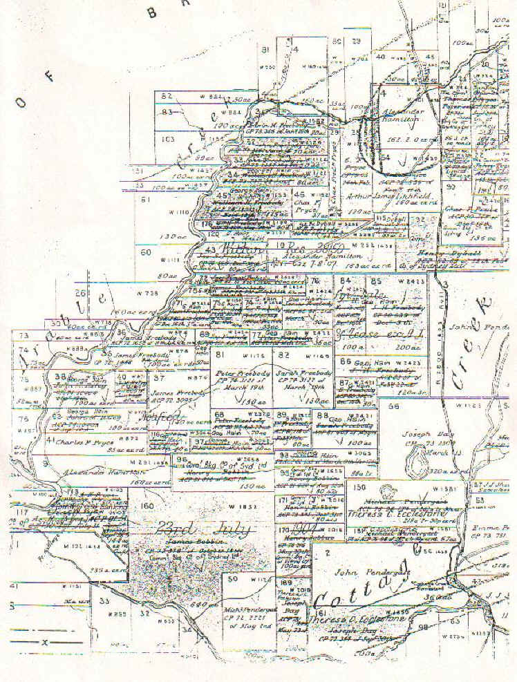
Parish Maps
There are over 7000 parish map sheets, and inevitably, there have been name
duplications; therefore, it is essential always to identify a parish by both its
and the county’s names. The parish is divided into portions, the numbers of
which are shown on the map face. There are more portions in a closely settled
area than in some of the more sparsely occupied parts of the State. When a town
lies within a parish, its location is indicated but relevant information is
shown on a more detailed scale in a town or village map. The breakdown is
usually into sections and allotments rather than portions. Maps are not produced
for "private" towns which have been subdivided out of privately owned
land. In recent year’s portions, allotments and sections have given way to the
better known real property system terms "lots" within "deposited
plans", but this is of little significance to most researchers.
Arable 1